My expertise is in geographic information systems (GIS) and remote sensing with a focus on unmanned aerial vehicle (UAV)-based data acquisition and image analysis. Currently, I mentor FAU High School students engaged in undergraduate research at Florida Atlantic University and conduct my own research in watershed hydrology and airborne VNIR imaging spectroscopy. Prior to coming to academia, I gained industry experience in geospatial data science and analytics at AECOM while supporting projects for NASA, U.S. Air Force, U.S. Navy, Florida DOT, and local municipalities. My application of geospatial technologies focuses on transportation, water resources, environmental management, energy and communications infrastructure.
Download my CV.
- Remote Sensing
- Photogrammetry
- GIS, Spatial Data Science
- Unmanned Aircraft Systems
-
MS in Civil Engineering, 2021
Florida Atlantic University
-
BS in Geomatics Engineering, 2020
Florida Atlantic University
Research
Experience
- Areas of expertise: geospatial data science and analytics in ArcGIS Pro/Desktop, Python and R programming, unmanned aircraft systems (UAS) and GPS/GNSS field data collection.
- Supported projects in transportation, water resources, environmental management, energy and communications infrastructure (see CV for details).
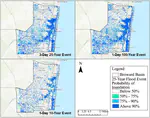
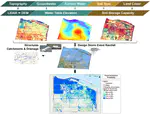
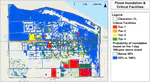
- Integrated GIS with hydrologic-hydraulic modeling for probabilistic prediction of localized flood response to storm events in watersheds across Florida.
- Processed LiDAR-derived topography, modeled groundwater using regression analysis, classified impervious surfaces using multispectral imagery, calculated soil storage, and utilized Arc Hydro for drainage routing and infrastructure in ArcGIS Pro.
- Assisted the City of Clewiston with advanced modeling tools for assessing stormwater risk and solutions to design a NFIP CRS plan for floodplain management.
- Prepared maps and technical reports to support the development of watershed-based flood protection plans across Florida (CWR3).
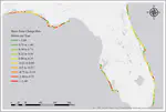
- Georeferenced historical land surveys and digitized positions of Florida’s coastline.
- Calculated change rate statistics using ArcGIS Desktop and the USGS Digital Shoreline Analysis System to analyze movement over time and investigate driving factors.
Teaching
Courses Taught
- EDF 2911: Multidisciplinary Research Methods 1
- EDF 2910: Introduction to Research
The Multidisciplinary Research Methods course series connects undergraduates with faculty researchers, teaches primary literature search and analysis, and mentors students as they write grant proposals, present at conferences, and co-author publications. This unique program is offered to high school students.